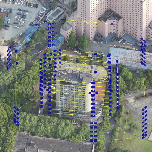
Managing multiple unmanned aerial vehicles (UAVs) requires more than knowing where each aircraft is flying. Fleet operators must coordinate routes, monitor mission progress, maintain communication, and respond to changing conditions across the operating area. As drone deployments expand in surveying, infrastructure inspection, and emergency response, real-time tracking has become an important part of operational management. Combining accurate positioning with onboard computing and coordinated mission planning helps teams maintain a clearer view of fleet activity and allocate resources more effectively.
Why Real-Time Tracking Matters for Fleet Operators
When several drones operate simultaneously, a single aircraft’s location provides only part of the operational picture. Fleet managers also need to understand each UAV’s assigned task, progress, and relationship to other aircraft. Delayed updates can complicate coordination, particularly during large-area surveys or emergency deployments where teams must respond to changing field conditions.
Effective UAV tracking combines location information with mission status and communication between airborne platforms and ground control. The Federal Aviation Administration’s Remote ID framework illustrates the importance of aircraft identification and location information in the wider drone ecosystem. However, regulatory Remote ID and operational fleet management serve different purposes and should not be treated as interchangeable.
Integrating UAV Positioning with Air-Ground Coordination
Reliable fleet monitoring depends on a coordinated architecture linking aircraft, communication systems, onboard computing, and ground-based command tools. UAV positioning supplies geographic information, while communication and control functions help operators interpret that information and manage mission execution.
Positioning quality depends on factors such as satellite visibility, sensor performance, environmental conditions, and the navigation methods available on each aircraft. Fleet operators should evaluate location accuracy, update frequency, communication coverage, and recovery procedures against the demands of their missions.
Icecypress Technology’s DroneSwarm Real-Time Onboard Analysis System combines onboard processing with ground-side mission management. The system supports integrated Communication, Navigation, and Control (CNC), coordinated multi-UAV operations, and real-time tracking and positioning. These functions provide a foundation for managing distributed aerial data collection.
Coordinating Different Aircraft and Flight Plans
Fleet operators may need to deploy multirotor, fixed-wing, and hybrid UAV platforms within the same operational environment. Each configuration has different flight characteristics and mission suitability, so dispatch decisions must account for endurance, payload, terrain, coverage requirements, and launch conditions.
DroneSwarm supports coordinated deployment of these different UAV types. Its mission-planning capabilities also support route generation based on aircraft performance, terrain, and operational requirements. When conditions change, mission replanning and fleet reorganization can help operators adapt task assignments and flight routes.
For large-area surveying, dividing the work among several aircraft can improve coverage efficiency when route overlap, task allocation, and data consistency are properly managed. Fleet software should also account for safe separation, communication interruptions, and the possibility that an aircraft may need to leave the mission.
From Tracking Data to Useful Operational Information
Aircraft locations become more valuable when connected with the information collected during flight. Live mapping, target recognition, and geolocation can help operators understand not only where drones are operating, but also what they are observing.
DroneSwarm supports collaborative real-time 2D and 3D mapping and reconstruction, alongside target recognition, positioning, and tracking. These capabilities can support surveying, infrastructure inspection, and emergency response by linking aerial observations with geographic context.
For example, an emergency team could use updated spatial information to review accessible areas and locate relevant objects. Surveying teams could monitor coverage while coordinating data collection across a large site. Results still require appropriate verification, especially when visibility is poor, objects are partially obscured, or positioning uncertainty affects interpretation.
Evaluating a Fleet Monitoring Platform
Before adopting a fleet management system, B2B buyers should assess how well it fits their aircraft, operating environment, and existing workflows. Key considerations include:
Location and tracking performance: Assess update latency, positioning accuracy, and the quality of location data under expected field conditions.
Interoperability: Check compatibility with aircraft types, communication links, mapping tools, and ground-control infrastructure.
Mission coordination: Review route allocation, task reassignment, and the procedures available when conditions change.
Data handling: Examine how imagery, reconstructed models, target information, and mission records are stored and shared.
Operational resilience: Evaluate communication-loss procedures, operator oversight, and relevant aviation requirements.
These checks help organizations distinguish a live location display from a more comprehensive operational system.
Making Multi-UAV Operations More Coordinated
Real-time fleet management brings together location awareness, mission planning, onboard analysis, and ground-based coordination. For organizations operating multiple aircraft, the objective is to turn separate flight activities into a coherent workflow that supports timely, informed decisions.
Icecypress Technology‘s DroneSwarm system combines multi-UAV collaboration, spatial data processing, and unified command capabilities for professional applications. By assessing tracking performance, integration needs, and operational procedures together, fleet operators can determine whether the platform fits their requirements for surveying, inspection, or emergency response.
